The Environment Agency’s Climate Change Allowances Guidance in relation to peak rainfall intensities was significantly updated on the 10th May 2022 adopting a Management Catchment approach in England, rather than a National Scale application which was previously utilised.
Our Water Resources Team have reviewed these changes and summarise what they are and how do they could potentially impact development proposals:
Climate change allowances were previously applied on a National Scale across the whole of England. The country has now been divided into 92 Catchment Management areas, each with its own set of climate change allowance values, which aligns with the methodology adopted for delineating peak river flow allowances. They have also given different climate change allowances for the 1 in 30 year and 1 in 100 year events and further to this, the epochs that the climate change should be applied to has also been reduced from three to two.
The updated guidance seeks to simplify how climate change should be applied by type of development, stating that:
-
- Use the development lifetime guidance to work out the lifetime of your development
- You should consider residential development to have a minimum lifetime of a 100 years
- Design your development so that for the upper end allowance in the 1 in 100 year exceedance probability event:
- there is no increase in flood risk elsewhere
- your development will be safe from surface water flooding
- For development with a lifetime between 2061 and 2100 take the same approach, but use the central allowance for the 2070s epoch (2061 to 2125)
- For development with a lifetime up to 2060, take the same approach but use the central allowance for the 2050s epoch (2022 to 2060)
- In some locations the allowance for the 2050s epoch is higher than that for the 2070s epoch. If so, and development has a lifetime beyond 2061, use the higher of the two allowances
Potential Implications
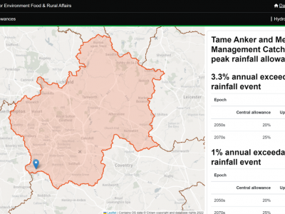
In simple terms, the new climate change allowances are applied on a Management Catchment basis. This could mean that two sites in two different Management Catchments, but in relatively close proximity to each other, could require different climate changes allowances to be applied. These values are now provided within a new online GIS tool, an extract of which is contained below.
At present there is no guidance on how to apply the climate change allowance if a site sits between two Catchment Management Areas; however, it may be presumed that the higher climate change value is applied as a precautionary approach.
This means that drainage strategies and designs will now be potentially required to apply a 50% or 45% climate change allowance in rainfall will take immediate effect. This may have an impact on your current and proposed drainage strategies currently.
These changes are aimed to protect development against flooding but will have a material impact on the size and form of attenuation facilities that in turn will affect development masterplan layouts.
Further Questions?
For further information on these changes or clarification on the implications of these changes to your proposed develop site, please contact our water resources team:
Jerry Muscroft, E: [email protected] T: 07732 601 245
Andrea Nelmes, E: [email protected] T: 07999 830 246
Phoebe Ryding, E: [email protected] T: 07872 858 452
Malcolm Crowther, E: [email protected] T: 07876 235 111
Find out more about our services here
Sign up for more news from PJA here
Find out more
For more information, please contact our water resources team: